Author Archives: admin

1942 Aerials of Sonoma County - Santa Rosa Plain

Fearing a west coast invasion during World War II, the U.S. Department of War collected airphotographs of all of Sonoma County in 1942.  These photos are the earliest complete image of Sonoma County. The photos were collected on film and printed as thousands of hard copy (9" x 9") photos. Two complete hard copies remain - one at the University of California Berkeley and the other at Draftech in Santa Rosa.

Through a grant from the Sonoma County Water Agency and the Sonoma County Agricultural Preservation and Open Space District, the San Francisco Estuary Institute (SFEI) has digitized, georeferenced, and mosaiced a subset of the photos - those that comprise the Santa Rosa Plain. This dataset is useful for all manner of historical analysis such as understanding changes in land use and population, and tracking changes in vegetation and habitat over time.

Check out the embedded map below (click here for the full version) to easily compare what things looked like in 1942 to what they look like today in the Santa Rosa Plain. Watch out - it's addicting! You can also download the air photography here (700 MB .img file).  If you want to use the photography as an ESRI image service, search ArcGIS.com for 'Sonoma County 1942'.

Click here for the full version

Overview of Vegetation Mapping Methods

The Sonoma County Vegetation and Habitat Mapping Program will use a state of the art mapping approach that combines on the ground field data collection with modern semi-automated mapping techniques. The semi-automated approach leverages the power of today's expert systems and machine learning algorithms to automate the mundane and laborious parts of vegetation mapping, such as delineating stand boundaries and labeling obvious features, saving valuable expert labor for the more subtle and difficult components of mapping.

Field Data Collection to Support Mapping
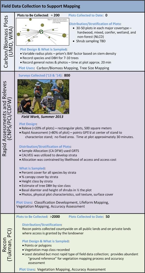
Field work is a critical component to any vegetation mapping project. As shown in Figure 1 (below), there are three types of field data that will be collected and utilized for vegetation mapping: carbon/biomass plots, rapid assessment and releve plots, and reconnaissance (recon). Variable radius plots will be collected using a prism to support the biomass and carbon mapping being conducted by Dr. Ralph Dubayah (University of Maryland) under a NASA Roses Grant. These plots will accurately measure living biomass across Sonoma County's woody habitats. The biomass measurements will be used by Dr. Dubayah's team to develop models that will be used to map woody biomass across all of Sonoma County.

Rapid assessment and releve plot collection will provide a base of very detailed species composition information across the county's habitats - these plots will be used to refine the rules and descriptions for Sonoma County's vegetation types, resulting in a classification (based on A Manual of California Vegetation), a dichotomous key, and type descriptions. The rapid assessment and releve plots - along with extensive field reconnaissance data - will be used for all phases of the vegetation mapping process, as well as for accuracy assessment. Sonoma Veg Map is lucky to be the beneficiary of an in-kind grant from the California Department of Fish and Wildlife's Vegetation Mapping and Classification Program (VegCAMP). VegCAMP, led by Dr. Todd Keeler-Wolf, has played and will continue to play an instrumental role in field data collection, plot data analysis, and classification development for Sonoma Veg Map.

Figure 1 - Field Data Collection
plots

Lifeform Mapping
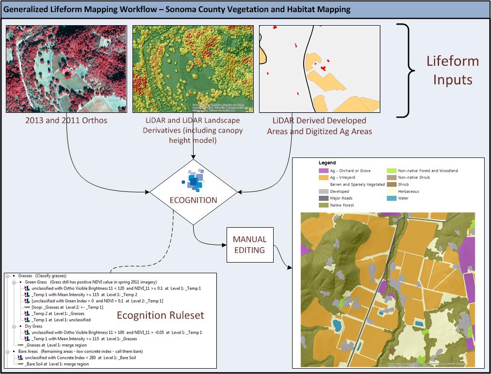
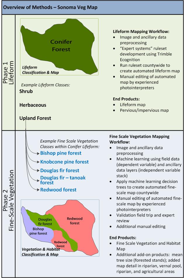
Mapping will occur in two phases: lifeform mapping and fine-scale vegetation mapping (see Figure 3 at the end of this post). The lifeform map serves as the foundation for the much more detailed fine-scale vegetation map. The lifeform map utilizes "expert systems" rulesets that are developed in Trimble Ecognition. These rulesets combine automated image segmentation (stand delineation) with object based image classification techniques. In contrast with machine learning approaches, expert systems rulesets are developed heuristically based on the knowledge of experienced image analysts.  Key data sets that will be used in the expert systems rulesets for lifeform include:  orthophotography ('11 and '13), the LiDAR derived Canopy Height Model (CHM), and other LiDAR derived landscape metrics. Figure 2 shows the lifeform mapping workflow.

After it is produced using Ecognition, the preliminary lifeform map product is manually edited by photointerpreters. Manual editing corrects errors where the automated methods produced incorrect results. Edits are made to correct two types of errors: 1) unsatisfactory polygon (stand) delineations and 2) incorrect polygon labels.

The lifeform map classifies the landscape into the following basic cover type classes:

  • Urban Window
  • Water
  • Barren & Sparsely Vegetated
  • Major Road
  • Developed
  • Orchard or Grove
  • Vineyard
  • Vineyard Replant
  • Annual Cropland
  • Perennial Agriculture
  • Irrigated Pasture
  • Intensively Managed Hayfield
  • Nursery or Ornamental Horticultural Area
  • Native Forest
  • Non-Native Forest
  • Shrub
  • Non-Native Shrub
  • Herbaceous

The impervious surface map, a separate Sonoma Veg Map product, will provide very detailed delineations of impervious surfaces, with a minimum mapping unit of 1000 square feet.  Impervious surfaces will be mapped using the following classes:

  • Buildings
  • Dirt and Gravel Roads
  • Paved Roads
  • Other Impervious

Figure 2 - Lifeform Mapping Workflow
Mapping Workflows - General

Fine-Scale Vegetation Mapping
The second phase of mapping refines the lifeform product into a fine-scale vegetation map. This process relies on machine learning algorithms which identify and exploit correlations between field surveyed vegetation and a "stack" of independent variables derived from ancillary geospatial data sets. The resulting machine-learning-based model is applied to the entire landscape, resulting in a preliminary fine-scale vegetation map.  Machine learning algorithms utilized for this process will include Classification and Regression Tree Analysis (CART) and Random Forests.  The independent variables used for this project will include the following:

  • Spectral bands and indices (means and stand deviations) derived from 2011 and 2013 orthophotography
  • Spectral bands and indices derived from multi-temporal Landsat imagery
  • Key spectral indices from AVIRIS (hyperspectral) - Thanks Dr. Matthew Clark for access to this data!
  • Canopy volume profiles derived from the LiDAR point cloud
  • LiDAR derived slope and aspect
  • LiDAR derived elevation
  • LiDAR derived landscape metrics
  • MODIS-derived fog/cloud frequency (thanks to Dr. Eric Waller for providing this data set!)
  • Shape indices that characterize stand shape, derived from Trimble Ecognition
  • Numerous layers from the California Basin Characterization Model (BCM), including average annual precipitation and climate water deficit
  • Horizontal distance from coastline

After it is produced the machine learning approach, the preliminary fine scale vegetation map product is manually edited by photointerpreters.  Manual editing corrects errors where the automated methods produced incorrect results. Edits are made to correct two types of errors: 1) unsatisfactory polygon (stand) delineations and 2) incorrect polygon labels. After an initial round of editing is complete, draft maps are reviewed by local experts and field crews are dispatched for a final round of map review. Based on input from local experts and notes from the final map review, the fine-scale vegetation map is manually edited one final time before delivery.

Figure 3 - Overview of Methods
methods

Local Ecology and Botany Advisory Group Meets

The Local Ecology and Botany Advisory Group - 35 experts in ecology, botany, and land management - convened at the Laguna Foundation's Heron Hall in late January to advise the vegetation and habitat mapping team. The advisory group's primary role is to provide expert local botanical and ecological insight to help make the most comprehensive, accurate, useful map possible.

The meeting began with presentations by members of the mapping team (Tom Robinson, Mark Tukman, and Joan Schwan) followed by breakout sessions. In the breakout sessions, committee members advised the mapping team on possible locations for field work, occurrences of unique or rare vegetation communities, and existing fine-scale vegetation data for use by the mapping team. Committee members also provided valuable input on strategies for maximizing the usability of the vegetation and habitat map.

Thanks to our ecologists and botanists for donating their time and expertise to help us make the best map! See below for a list of Local Ecology and Botany Advisory Group Members.

Name Affiliation
Aaron Arthur Consulting botanist
Ann Howald Consulting botanist
Arthur Dawson Baseline Consulting
Brendan O'Neil California State Parks
Caroline Christian Sonoma State University
Chris Kjeldsen Consulting botanist
Christina Sloop San Francisco Bay Joint Venture
Claudia Luke Sonoma State University
Cyndy Shafer California State Parks
Dave Cook Sonoma County Water Agency
Fred Euphrat Consulting forester
Gene Cooley CA Department of Fish and Wildlife
Hattie Brown Laguna Foundation
Jane Valerius Consulting botanist
Joe Pecharich NOAA/NMFS
John Herrick CNPS Milo Baker Chapter
Julian Meisler Sonoma Land Trust
Kate Symonds USFWS, Partners for Fish & Wildlife
Kathleen Kraft Sonoma Marin Coastal Grasslands Working Group
Keenan Foster Sonoma County Water Agency
Liz Parsons CNPS Milo Baker Chapter
Mariska Obedzinski UCCE/CA Sea Grant
Michelle Halbur Pepperwood Preserve
Peter Baye Consulting botanist
Peter Connors UC Davis Bodega Marine Lab
Peter Warner Consulting botanist
Phil Northen Sonoma State University
Phil van Soelen Cal Flora Nursery
Rich Stabler Sonoma County Permit and Resource Management Dept.
Roger Raiche Planet Horticulture
Sarah Gordon Consulting botanist, CNPS Milo Baker, project field crew
Shelly Benson Consulting botanist, project field crew
Sherry Adams Audobon Canyon Ranch
Steve Barnhart Pepperwood Preserve
Tom Parker San Francisco State University

Save the Redwoods League Provides Grant for Redwood Research in Sonoma County

SRL_logoSave the Redwoods League - through its conservation planning program - has provided funding for redwood related plot data collection and analysis in Sonoma County. The funding will result in the establishment of 12 permanent plots in redwood stands across the county. Sampled stands will be selected to represent a range of moisture regimes where redwood occurs in the county—from stands along the relatively moist coastline to the relatively drier pockets of redwood forests of eastern Sonoma County. The permanent plots will be established and designed with the objective of periodic re-sampling in mind. Plots will be 400 square meters (20m x 20m). Sampling will result in an inventory of all plants in the plot, and woody vegetation will be measured.

Data from the permanent plots will be used to monitor trends in redwood forest composition over time—which is important for tracking the effects of climate change on our region's most iconic habitat type. The plot data will also be used to accurately characterize redwood forests in the Sonoma County vegetation and habitat map. These data will augment a growing body of vegetation plot data in Sonoma County being collected by the California Department of Fish and Game's Vegetation Classification and Mapping Program, the California Native Plant Society, Pepperwood Foundation, Prunuske Chatham, Inc., Sonoma State University (Dr. Matthew Clark), and the University of Maryland (Dr. Ralph Dubayah). These data will help to support the ongoing development of Sonoma County's vegetation and habitat map.

The permanent redwood plots will provide for a better understanding of redwood vegetation associations, their biotic components, and their patterns and distributions in Sonoma County. The sampling, classification, and mapping of redwood vegetation will raise awareness of their importance and rarity, identify threats to their existence, and allow for conservation of biodiversity at the "multi‐species" landscape level. Establishing a vegetation sampling array provides a scientific baseline for assessing and monitoring the overstory and understory components of redwood forests in the region. Future resampling will allow for the detection and mitigation of changes in redwood forests that may result from climate change. This project will also support other projects in the county aimed at demonstrating the value of the county's forests to carbon sequestration and other reductions in greenhouse gases.

For more information contact:
Julie Evens, California Native Plant Society
Lisa Micheli, Pepperwood Preserve
Mark Tukman, Tukman Geospatial LLC
Tom Robinson, Sonoma County Agricultural Preservation and Open Space District

Dr. Jordan Golinkoff Joins Veg. Mapping & Remote Sensing Advisory Committee

The Vegetation Mapping and LiDAR Program is thrilled to welcome Dr. Jordan Golinkoff as the newest member of our Vegetation Mapping and Remote Sensing Advisory Committee.

Dr. Jordan Golinkoff

The committee advises the mapping team on state-of-the art mapping techniques and methods. Dr. Golinkoff is an expert at using LiDAR to help map, measure, and manage forestland in Northern California. A Forest Carbon Analyst for the Conservation Fund, Dr. Golinkoff will add to the Advisory Committee's LiDAR and forest mapping expertise.

Dr. Golinkoff is one of the nation's leading experts on forest carbon project development, monitoring, and verification. He joined The Conservation Fund in 2005 and has extensive experience in forest inventory and projection methodologies, statistical analysis, and carbon accounting practices and standards compliance. A trained forester and Climate Action Reserve and California Air Resources Board approved verifier, Jordan is responsible for forest inventory design and carbon offset registration for The Conservation Fund, the nation's largest seller of verified forest carbon offsets. Jordan has a B.A. in Computer Science from Yale University, a Masters of Forestry from Duke University, and a Ph.D. in forest mensuration and biometrics from the University of Montana.

Vegetation Mapping and Remote Sensing Advisory Committee

The Sonoma County Vegetation Mapping Program is excited to announce our Vegetation Mapping and Remote Sensing Advisory Committee!  This committee will provide expert technical advice to the District and mapping team throughout the course of the project.  Our committee members have deep expertise in varied fields including remote sensing, botany, ecology, wildlife, carbon mapping, forestry, and GIS.  We are thrilled to have such a high caliber group of advisers to guide us as we map the vegetation and habitats of Sonoma County.  The district and the mapping team is in the process of forming other committees and working groups that will provide specific guidance and expertise;  these committees will be introduced as they are established.  The table below lists the Vegetation Mapping and Remote Sensing Advisory committee members, their affiliations, and their particular areas of expertise.

[table "" not found /]