|
|
|
Spring Newsletter - May 19, 2017
|
|
|
|
|
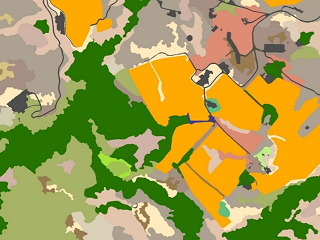
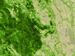
Fine-Scale Vegetation and Habitat Map Now Available
The Vegetation and Habitat map provides a fine-scale representation of
natural vegetation in Sonoma County. The fine-scale map has 212,391
polygons countywide, and represents 83 different vegetation communities and land
cover types. The map was created using a combination of field work, aerial photo
interpretation, and computer-based modeling and machine learning. The map is based on a
vegetation key developed by
the California Department of Fish and Wildlife and the California
Native Plant Society for the Sonoma Veg Map Program.
The Fine-Scale Vegetation and Habitat map is the culmination of several years of hard
work by a team led by the Sonoma County Agricultural Preservation and Open Space District and the
Sonoma County Water Agency.
The Fine-Scale Vegetation and Habitat map is available as watershed downloads and countywide downloads
from sonomavegmap.org.
Fine Scale Veg and Habitat Datasheet
Fine Scale Veg Poster PDFs
|
|
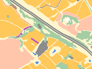
Updated Lifeform and Croplands and a New 'Forest' Lifeform
The Lifeform and Cropland maps have been updated. The new versions of these
datasets are still based on the 2013 orthophotography and LiDAR, but the datasets were refined and improved during manual
editing of the fine-scale vegetation and habitat map.
The new 'forest lifeform' map offers a level of detail for forested lands between the very floristically detailed fine scale map
and the lifeform map. You may find the forest lifeform map useful for cartography or analysis where you need more natural land detail
than the lifeform map provides, but don't need the full detail of the Fine-Scale Vegetation and Habitat map.
The lifeform and croplands maps are available as watershed downloads and countywide downloads
from sonomavegmap.org.
Lifeform and Forest Lifeform Datasheet
Croplands Datasheet
|
|
|
|
|
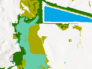
Water and Wetland Vegetation
The water and wetland vegetation data product represents water, herbaceous
wetland vegetation, and woody wetland vegetation. The layer is derived directly from the Fine-Scale Vegetation and
Habitat map, and represents the state of the landscape in fall, 2013 (a very dry period). Water in this data product is classified into several classes - river water, lake/reservoir water,
estuarine water, and ocean water. Note that due to the 2011-2017 drought, this data product provides a conservative mapping of herbaceous wetlands
greater than 1/4 acre in area.
The water and wetlands data are available as watershed downloads and countywide downloads from sonomavegmap.org.
Water and Wetland Vegetation Datasheet
|
|
Aboveground Carbon and Biomass Maps
The Carbon and Biomass maps (3 data products) are 30-meter rasters with pixel values that represent
metric tons of biomass per hectare, metric tons of carbon per hectare, and carbon equivalents per hectare.
The carbon and biomass products were developed by Dr. Ralph Dubayah and his team
at the University of Maryland as part of the NASA Roses Grant
that also funded high resolution imagery and
the LiDAR point cloud for Sonoma County. The Carbon and Biomass maps are based on models trained on field-collected Sonoma County biomass
plots collected specifically for this project.
The Carbon and Biomass maps are available as watershed downloads and countywide downloads from sonomavegmap.org.
Biomass & Carbon Map Datasheet
|
|
|
|
|
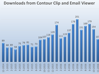
Value of Sonoma Vegetation Map and LiDAR Program Report
Check out this newly released report that provides a comprehensive overview of the value of the LiDAR and Veg Map data products to diverse users in Sonoma County.
The report, titled Use and Value of Sonoma County’s Vegetation Mapping and Lidar Program Products,
was developed by Kass Green and Associates for the Sonoma County Agricultural Preservation and Open Space District.
The report is based on a survey of data users and follow up interviews with a number of the users of the data. Thanks to the 93 of you who participated in
in the survey!
The report provides statistics on the number of requests for the Sonoma Veg Map data products, the types of users,
what the data are being used for, and the value of the data to users.
Value of Sonoma Veg Map Data Products Report
|
|
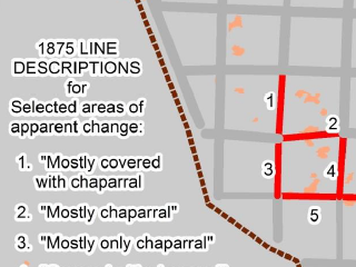
Historical Vegetation in the Mayacamas
Arthur Dawson, a historian and historical ecologist from Glenn Ellen, has produced a report
that compares the vegetation of Sonoma County in the 19th Century with today's vegetation. At this
time, Arthur has completed his work for a pilot area in the Mayacamas Mountains of northeastern
Sonoma County.
To create the historical ecology maps, Arthur compared data from the General Land Survey
with present day vegetation data from the Sonoma County Vegetation and Habitat Map.
The General Land Survey was conducted in the latter half of the 1800's and provides
detailed information about vegetation from points along transects that follow section lines of the Public Lands Survey System (PLSS).
Arthur's report is a fascinating glimpse into the past landscapes of Sonoma County!
Link to Historical Vegetation Pilot Report
|
|
|
|
Final Veg Map Accuracy Assessment and Report
In the coming months, the Sonoma Veg Map team will complete an accuracy assessment for the Fine-Scale Vegetation and Habitat map.
The accuracy assessment will include user's and producer's evaluation of accuracy for the more common fine scale map classes, as well
as overall map accuracy.
After the accuracy assessment is completed, it will be published along with a final report and methods document for the
Fine-Scale Vegetation and Habitat map.
|
|
|
|