Vegetation Mapping and LiDAR Program Meets Funding Goals
The Sonoma County Agricultural Preservation and Open Space District, the Sonoma County Water Agency and their partners have worked together to procure the necessary funding for all program elements including the
vegetation and habitat map, LiDAR (Light Detection and Ranging), and a suite of additional next-generation data products that include high resolution topography,
building outlines, roads, and high resolution imagery. Once collected and processed, all data from the program will be publicly available. State and federal partners are responsible for
funding approximately 58% of the program, with the remaining 42% from Sonoma County partners. The core funding for the LiDAR data products comes from
a NASA grant to the University of Maryland. For more information on the NASA grant, see our press release. For the complete
list of data products that this program will produce, click here.
The list of program funding partners includes the Sonoma County Agricultural Preservation and Open Space District, the Sonoma County Water Agency, the California Department of Fish and Wildlife,
the United State Geological Survey, the Sonoma County Information Systems Department, the Sonoma County Transportation and Public Works Department,
the Nature Conservancy, the City of Petaluma, NASA, and the University of Maryland.
For more information see the program web site.
back to top
Over 500 Vegetation Plots Collected in Summer/Fall 2013
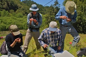
The California Department of Fish and Wildlife, the California Native Plant Society (CNPS), and Prunuske Chatham, Inc. (PCI) are wrapping up our first field season. In all, field crews
collected over 500 vegetation plots throughout the county across the gamut of the county's vegetation communities.
The field plots will provide the raw data that vegetation ecologists at the Department of Fish and Wildlife, CNPS, and PCI will use to develop accurate descriptions of all types of Sonoma County vegetation.
Plot data will also be analyzed to form the mapping classification (or legend) of the vegetation map.
back to top
LiDAR Acquisition Near Completion; Orthophoto Collection Complete
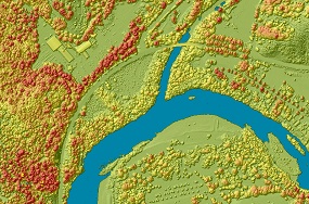
October's great weather has helped our consultant, Watershed Sciences, Inc., to complete collection of 4-band 6 inch resolution aerial photography for all of Sonoma County. As of November 8th,
WSI had also completed collection of high density airborne LiDAR data for about 70% of the county - WSI will complete LiDAR collection in November.
After data collection, WSI will analyze the raw data to create a number of derived products including high-resolution topography, building outlines, and 1-foot contours. Once created,
all datasets will be publicly available.
Analysts will rely heavily on the LiDAR data and the 2013 aerial photography during the process of vegetation mapping. For more information on LiDAR, see our
LiDAR blog post and the presentations from our
LiDAR and Environmental Data Forum.
back to top
Dr. Jordan Golinkoff Joins Advisory Committee
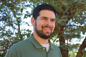
The Vegetation Mapping and LiDAR Program is thrilled to welcome Dr. Jordan Golinkoff as the newest member of our Vegetation Mapping and Remote Sensing Advisory Committee.
The committee advises the mapping team on state-of-the art mapping techniques and methods. Dr. Golinkoff is an expert at
using LiDAR to help map, measure, and manage forestland in Northern California. A Forest Carbon Analyst for the Conservation Fund, Dr. Golinkoff will add to the Advisory Committee's LiDAR and forest mapping expertise.
back to top
|