Sonoma County Vegetation Mapping and LiDAR Program Snapshot
The Sonoma County Agricultural Preservation and Open Space District, the Sonoma County Water Agency, the California Department of Fish and Wildlife, and the United State Geological Survey,
in collaboration with multiple agency and NGO partners have embarked on a 3-5 year program to map Sonoma County's topography, physical and biotic features, diverse plant communities and habitats.
The data produced by this program - including countywide LiDAR data and a fine scale vegetation and habitat map - will provide an accurate, up-to-date inventory of the county's landscape features, ecological communities and habitats.
These foundational data sets are key to ensuring good planning and management for watershed protection, flood control, fire and fuels management, wildlife habitat conservation, climate change adaptation, and climate change mitigation.
The District, SCWA, CDFW, USGS, and TNC have contributed substantial funding for this program - over $1.4 million of a projected $2 million.
This collaborative group is seeking funding from other partners who share the goal for high resolution data for Sonoma County.
For more information see the program web site.
back to top
Vegetation Plot Data Collection Begins July 22
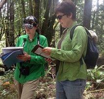
On July 22nd, The California Department of Fish and Wildlife's VegCAMP program began a data collection effort that will result in the collection of hundreds of vegetation plots across Sonoma County.
The Sonoma County Agricultural Preservation and Open Space District - with help from the California Native Plant Society (CNPS) and Prunuske Chatham - is assisting VegCAMP with plot data collection.
The field plots will form the basis for accurate descriptions of all types of Sonoma County vegetation.
Plot data will be analyzed to form the mapping classification (or legend) of the vegetation map.
back to top
LiDAR Effort Underway
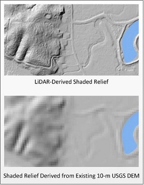
Airborne LiDAR (Light Detection and Ranging) uses advanced sensors and GPS technology to precisely measure the elevation of the ground as well as the height of vegetation, buildings, and other features.
LiDAR produces very accurate depictions of the earth's surface that have myriad uses ranging from vegetation mapping and forest monitoring to precision agriculture and flood inundation modeling.
LiDAR data has proven indispensable to many other states and counties: all nine Bay Area counties (except Sonoma) have LiDAR data as do a number of entire states.
The Sonoma County Agricultural Preservation and Open Space District and the Sonoma County Water Agency are currently working with other consortium members and interested parties to formulate the
specifications for a countywide LiDAR collection and a request for proposals (RFP) that will be put out for competitive bid to LiDAR vendors.
At this time, the goal is to have a LiDAR collect take place in late 2013 or early 2014. In this scenario, the LiDAR data would be available in late 2013 and associated vegetation map products would be produced in 2014 and 2015.
For more information on the benefits of LiDAR for Sonoma County, check out this LiDAR blog post and the presentations from our
LiDAR and Environmental Data Forum.
back to top
Lifeform Classification Rules and Key Complete
The first step in the creation of a fine scale vegetation map is to create a lifeform map. Lifeform types are broad classes such as evergreen forest, deciduous forest, and riparian forest.
The lifeform map serves as an initial stratification of the landscape and a foundation for later more detailed mapping.
During winter and spring 2013 the Sonoma County Agricultural Preservation and Open Space District's vegetation mapping team worked with the program's Vegetation Mapping and Remote Sensing Advisory Committee to develop and finalize the lifeform classification rules and key.
Special thanks to Dr. Todd Keeler Wolf (CDFW) and Mark Rosenberg (FRAP), who were instrumental in the development of this classification. The classification rules are available here.
back to top
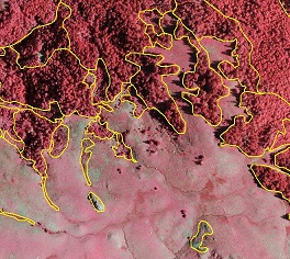
2011 High Resolution Imagery
In 2011, Sonoma County acquired countywide high resolution aerial imagery. The image acquisition was funded through a collaboration between USGS, Sonoma County PRMD, the Sonoma County Water Agency,
the Sonoma County Agricultural Preservation and Open Space District, the Town of Windsor, the City of Petaluma, and the City of Santa Rosa.
The imagery is used by numerous county agencies for many uses. The Vegetation Mapping and LiDAR Program will benefit greatly from the imagery throughout our mapping process.
Thanks to Dr. Maggi Kelly, Kevin Koy and the Geospatial Innovation Facility (GIF) at the University of California, Berkeley, for serving up the imagery until we can find a permanent home for the services!
The imagery is 4-band (near infrared, red, green and blue), with 6 inch spatial resolution for most of the county and 3-inch resolution in areas of Santa Rosa and Windsor.
For more information on the imagery and to view it, check out this blog post and this
web application.
back to top
|