LiDAR and Image Data Nearly Complete
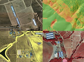
The Sonoma County Agricultural Preservation and Open Space District, the Sonoma County Water Agency and their partners have nearly completed
a suite of next-generation data products that include high resolution topography, LiDAR,
building outlines, roads, and high resolution imagery. The LiDAR data, imagery and a number of the other data products will be instrumental in the development of the vegetation and habitat map.
Once these datasets are fully delivered by Watershed Sciences, Inc. (WSI) and QA/QC is complete early this spring, the data products will be made
public. Subscribers to our email lists will be notified when the data becomes available. If you're not yet a subscriber,
click here.
For the complete list of data products that will be produced, click here. For more background on LiDAR check
out this blog post or this basic one page LiDAR primer. For more in-depth
information, check out the presentations from our
LiDAR and Environmental Data Forum held last spring.
Funding partners that contributed to this data collection include the Sonoma County Agricultural Preservation and Open Space District, the Sonoma County Water Agency, the California Department of Fish and Wildlife,
the United State Geological Survey, the Sonoma County Information Systems Department, the Sonoma County Transportation and Public Works Department,
the Nature Conservancy, the City of Petaluma, NASA, and the University of Maryland.
For more information see the program web site.
Save the Redwoods League Provides Grant for Redwood Research
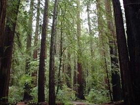
Save the Redwoods League - through its conservation planning program - has provided funding for redwood related plot data
collection and analysis in Sonoma County. The funding will result in the establishment of 12 permanent plots in redwood stands across the county.
Sampled stands will be selected to represent a range of moisture regimes where redwood occurs in the county - from stands along the relatively moist
coastline to the relatively drier pockets of redwood forests of eastern Sonoma County. The permanent plots will be established and designed with the objective of periodic re-sampling in mind.
Plots will be 400 square meters (20m x 20m). Sampling will result in an inventory of all plants in the plot, and woody vegetation will be measured.
Data from the permanent plots will be used to monitor trends in redwood forest composition over time - which is important for tracking the effects of
climate change on our region's most iconic habitat type. The plot data will also be used to accurately characterize redwood forests in the Sonoma County vegetation and habitat map.
These data will augment a growing body of vegetation plot data in Sonoma County being collected by the California
Department of Fish and Wildlife's Vegetation Classification and Mapping Program, the California Native Plant Society, Pepperwood Foundation, Prunuske Chatham, Inc.,
Sonoma State University (Dr. Matthew Clark), and the University of Maryland (Dr. Ralph Dubayah). These data will help to support the ongoing development of Sonoma County's vegetation and habitat map.
For more information, check this blog post.
back to top
Local Ecologists and Botanists Advise Mapping Team
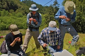
The Local Ecology and Botany Advisory Group - 35 experts in ecology, botany, and natural resources management - convened at the Laguna
Foundation's Heron Hall in late January to advise the vegetation and habitat mapping team. The meeting began with presentations by members of the mapping team
(Tom Robinson, Mark Tukman, and Joan Schwan) followed by breakout sessions. In the breakout sessions, committee members advised the mapping team on possible locations for field work,
occurrences of unique or rare vegetation communities, and
existing fine-scale vegetation data for use by the mapping team. Committee members also provided valuable input on strategies for maximizing the usability of the vegetation and habitat map.
For a list of Ecology and Botany Advisory Group members, see this blog post.
Thanks to our ecologists and botanists for donating their time and expertise to help us make the best map!
back to top
Remote Sensing and Veg. Mapping Experts Provide Input
In December, we held our second annual meeting of the Vegetation Mapping and Remote Sensing
Advisory Committee. This committee - composed of a "dream team" of mapping and remote sensing experts throughout the state of California -
provided input on the mapping team's proposed technical methods. Much of the discussion centered on the use of LiDAR, which is
revolutionizing the process of vegetation and habitat mapping. The mapping team received valuable input from the committee,
including state-of-the-art methods for distilling information from the LiDAR point cloud.
back to top
|