Classification Field Work Complete
In June, Sonoma Veg Map field crews completed classification field work, exceeding our sampling goal by collecting over 800 total surveys countywide. This completes two growing seasons
worth of data collection by the California Native Plant Society (CNPS), the California Department of Fish and Wildlife's Vegetation Mapping and Classification Program and local firm Prunuske Chatham, Inc.
These data will provide a base of detailed species composition information across the county's habitats and will be used to refine the rules
and descriptions for Sonoma County's vegetation types, resulting in a classification (based on A Manual of California Vegetation), a dichotomous key, and type descriptions.
The vegetation surveys - along with extensive field reconnaissance data - will be used for all
phases of the vegetation mapping process, as well as for accuracy assessment. Sonoma Veg Map is lucky to be the beneficiary of an in-kind grant from the
California Department of Fish and Wildlife's Vegetation Mapping and Classification Program (VegCAMP).
Led by Dr. Todd Keeler-Wolf, the VegCAMP crew has played and will continue to play an instrumental role in field data collection,
plot data analysis, and classification development for Sonoma Veg Map.
For more information about classification field data collection and vegetation mapping methods, click here.
back to top
New, High-powered Option to Access Sonoma County LiDAR Data
Starting in a few weeks, OpenTopography, a leading
portal to high-resolution topography data and tools, will begin to host and distribute Sonoma County's new LiDAR data.
Users of the data will have access to OpenTopography's excellent LiDAR data acquisition and analysis tools. Sonoma County's 30+ billion LiDAR returns will be added to OpenTopography's more than 700 billion hosted LiDAR returns!
Open Topography - funded by the National Science Foundation (NSF) and hosted at the San Diego Supercomputer Center - will provide users
access to the LiDAR data as Google Earth KMZs, standard DEM and hillshade products clipped to a user's area of interest (AOI), and the raw
or filtered point cloud for user defined AOIs.
Availability on OpenTopography complements a growing number of options for downloading Sonoma's County's LiDAR. For details on download options,
click here.
For the list of data products that are available now, click here. For more background on LiDAR check
out this blog post or this basic one page LiDAR primer. Also check out the presentations from our
LiDAR and Environmental Data Forum held last spring.
back to top
Digitized 1942 Airphotos Available for the Santa Rosa Plain
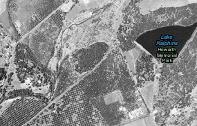
Fearing a west coast invasion during World War II, the U.S. Department of War collected aerial photography of all of Sonoma County in 1942.
These photos are the earliest complete image of Sonoma County. The photos were collected on film and printed as thousands of hard copy (9" x 9")
photos. Two complete hard copies remain - one at the University of California Berkeley and the other at Draftech in Santa Rosa. Through a grant from the
Sonoma County Water Agency and the Sonoma County Agricultural Preservation and Open Space District, the San Francisco Estuary Institute (SFEI) has
digitized, georeferenced, and mosaicked a subset of the photos - those that comprise the Santa Rosa Plain. This dataset is useful for all manner of historical
mapping assessments such as understanding changes in land use and population and tracking changes in vegetation and habitat over time.
Check out this
story map, which allows you to easily compare what things looked like in 1942 to what they look like today on the Santa Rosa Plain. Watch out - it's addicting!
You can also download the air photography here (500 MB .img file).
Or if you want to use the photography as an ESRI image service, load this layer file into ArcMap.
back to top
Lifeform Mapping Moving Forward
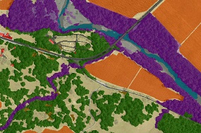
The mapping team has incorporated the new LiDAR data and orthophotography into the vegetation mapping process. The lifeform map - a map of cover type - is the next major
product of the program and will be complete in the Spring of 2015. The lifeform map serves as the foundation for the much more detailed
fine-scale vegetation map.
The mapping team has completed a pilot lifeform map of a few small areas of the county. At this time,
the Vegetation Mapping and Remote Sensing Advisory Committee
is reviewing the map of the pilot area.
Suggested workflow changes from the advisory committee will be integrated into the methods and
soon the mapping team will begin countywide production of the lifeform map.
To learn more about mapping methods, click here.
back to top
|