Category Archives: Botany

Local Ecology and Botany Advisory Group Meets

The Local Ecology and Botany Advisory Group - 35 experts in ecology, botany, and land management - convened at the Laguna Foundation's Heron Hall in late January to advise the vegetation and habitat mapping team. The advisory group's primary role is to provide expert local botanical and ecological insight to help make the most comprehensive, accurate, useful map possible.

The meeting began with presentations by members of the mapping team (Tom Robinson, Mark Tukman, and Joan Schwan) followed by breakout sessions. In the breakout sessions, committee members advised the mapping team on possible locations for field work, occurrences of unique or rare vegetation communities, and existing fine-scale vegetation data for use by the mapping team. Committee members also provided valuable input on strategies for maximizing the usability of the vegetation and habitat map.

Thanks to our ecologists and botanists for donating their time and expertise to help us make the best map! See below for a list of Local Ecology and Botany Advisory Group Members.

Name Affiliation
Aaron Arthur Consulting botanist
Ann Howald Consulting botanist
Arthur Dawson Baseline Consulting
Brendan O'Neil California State Parks
Caroline Christian Sonoma State University
Chris Kjeldsen Consulting botanist
Christina Sloop San Francisco Bay Joint Venture
Claudia Luke Sonoma State University
Cyndy Shafer California State Parks
Dave Cook Sonoma County Water Agency
Fred Euphrat Consulting forester
Gene Cooley CA Department of Fish and Wildlife
Hattie Brown Laguna Foundation
Jane Valerius Consulting botanist
Joe Pecharich NOAA/NMFS
John Herrick CNPS Milo Baker Chapter
Julian Meisler Sonoma Land Trust
Kate Symonds USFWS, Partners for Fish & Wildlife
Kathleen Kraft Sonoma Marin Coastal Grasslands Working Group
Keenan Foster Sonoma County Water Agency
Liz Parsons CNPS Milo Baker Chapter
Mariska Obedzinski UCCE/CA Sea Grant
Michelle Halbur Pepperwood Preserve
Peter Baye Consulting botanist
Peter Connors UC Davis Bodega Marine Lab
Peter Warner Consulting botanist
Phil Northen Sonoma State University
Phil van Soelen Cal Flora Nursery
Rich Stabler Sonoma County Permit and Resource Management Dept.
Roger Raiche Planet Horticulture
Sarah Gordon Consulting botanist, CNPS Milo Baker, project field crew
Shelly Benson Consulting botanist, project field crew
Sherry Adams Audobon Canyon Ranch
Steve Barnhart Pepperwood Preserve
Tom Parker San Francisco State University

Save the Redwoods League Provides Grant for Redwood Research in Sonoma County

SRL_logoSave the Redwoods League - through its conservation planning program - has provided funding for redwood related plot data collection and analysis in Sonoma County. The funding will result in the establishment of 12 permanent plots in redwood stands across the county. Sampled stands will be selected to represent a range of moisture regimes where redwood occurs in the county—from stands along the relatively moist coastline to the relatively drier pockets of redwood forests of eastern Sonoma County. The permanent plots will be established and designed with the objective of periodic re-sampling in mind. Plots will be 400 square meters (20m x 20m). Sampling will result in an inventory of all plants in the plot, and woody vegetation will be measured.

Data from the permanent plots will be used to monitor trends in redwood forest composition over time—which is important for tracking the effects of climate change on our region's most iconic habitat type. The plot data will also be used to accurately characterize redwood forests in the Sonoma County vegetation and habitat map. These data will augment a growing body of vegetation plot data in Sonoma County being collected by the California Department of Fish and Game's Vegetation Classification and Mapping Program, the California Native Plant Society, Pepperwood Foundation, Prunuske Chatham, Inc., Sonoma State University (Dr. Matthew Clark), and the University of Maryland (Dr. Ralph Dubayah). These data will help to support the ongoing development of Sonoma County's vegetation and habitat map.

The permanent redwood plots will provide for a better understanding of redwood vegetation associations, their biotic components, and their patterns and distributions in Sonoma County. The sampling, classification, and mapping of redwood vegetation will raise awareness of their importance and rarity, identify threats to their existence, and allow for conservation of biodiversity at the "multi‐species" landscape level. Establishing a vegetation sampling array provides a scientific baseline for assessing and monitoring the overstory and understory components of redwood forests in the region. Future resampling will allow for the detection and mitigation of changes in redwood forests that may result from climate change. This project will also support other projects in the county aimed at demonstrating the value of the county's forests to carbon sequestration and other reductions in greenhouse gases.

For more information contact:
Julie Evens, California Native Plant Society
Lisa Micheli, Pepperwood Preserve
Mark Tukman, Tukman Geospatial LLC
Tom Robinson, Sonoma County Agricultural Preservation and Open Space District

Sonoma County Serpentine

Serpentine communities occur in scattered areas across Sonoma County. These communities support a number of rare and endangered plant species.  From a vegetation mapping perspective, these are important areas.  Because thesy are small, geographically isolated, and occur uncommonly across the County's landscape, it will be important to clearly identify these areas and compile existing field data for them before our mapping work begins.  Serpentine areas on the North Coast have been studied significantly in the past 75 years, and much is known about their composition. In the April, 2009 issue of the Journal Fremontia (California Native Plant Society), Roger Raiche provides a great botanical profile of the Cedars, the county's largest serpentine area.

The serpentine areas of Sonoma County are associated with several soil types.  Among these are soils from the Henneke Series, soils from the Montara  series, and soils from the Huse series.

The interactive map below shows the 1997 Soil Survey Geographic (SSURGO) soils data overlaid on Bing aerial imagery.  Pan and zoom to move around on the map.  Access the "Bookmarks" to navigate to the major serpentine areas in the county.  If you click "View Larger Map," a larger map will open in ArcGIS.com with more functionality.  This map's default extent is an area of serpentine soils (mainly the Henneke series) and vegetation north of Occidental near the Bohemian Highway.

View Larger Map

Historical Wieslander Vegetation Maps

In the 1920s and 30s, forester A.E. Weislander led an effort to map vegetation across the State of California.  Though never completed, this effort resulted in set of maps, photos, and vegetation plot data for numerous areas throughout California.  This data set provides the best available snapshot of California vegetation during the early part of the 20th century.

The Wieslander Vegetation Type Mapping (VTM) Project, a project conducted jointly between UC Berkeley and UC Davis, has resulted in the digitization of the Wieslander plot data, photos and many of the vegetation map sheets.  The VTM project was jointly funded by the US Department of Agriculture and UC Berkeley.  Much of the GIS work for the Wieslander VTM project was undertaken by Dr. Maggi Kelley's laboratory at UC Berkeley.  Dr. Kelley serves as an Advisory Committee member for our Vegetation Mapping Program here in Sonoma County.

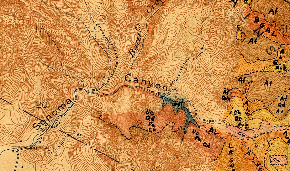
Example of a Wieslander Vegetation Map from Sonoma Valley

The Wieslander maps are of interest to the Sonoma County Vegetation Mapping Program because - once the Sonoma County map is produced - the Wieslander maps can be compared to the new Sonoma County Vegetation map to see how vegetation has changed in the past 70 years or so.

Wieslander plot data is limited to only 13 available plots in southern Sonoma County.  But Wieslander vegetation maps exist for a number of areas within the county, including the far northern section of the county, and the southeastern part including the southern Mayacamas Mountains.

In addition to digitizing the vegetation related data and photos, the University of California also has captured digital transcripts of interviews conducted with A.E. Weislander in 1985. These are fascinating to read.

To download the map or the plot data for Sonoma County, go to http://vtm.berkeley.edu/data/ and click "Data by County."